- Airport Transfers
For those who wish to book ahead of arrival or want to avoid the hassle (and hustle) at the airport, you can do so for your boat tickets as well as our ‘meet and assist’ service through our website. Please note that on submission of this form you will be directed to paypal to make […]
- Languages
Temne is spoken by the Temne, who make up about 30% of the population of Sierra Leone. The mainly hail from the country’s Northern Province and have a rich culture and history. A famous Temne Chief Bai Bureh launched a rebellion against the British in 1898, this was as a result of overtaxation of his […]
- Languages
Krio is the most widely spoken language in Sierra Leone and is native to the Creoles who are freed slaves from Britain, The United States and West Indies. It is mainly derived from English but has influences from other African languages (Yuroba for example), European languages (such as French) and also contains some expressions found […]
- Additional Resources
National Tourist Board Ministry of Tourism and Culture Ministry for Information and Broadcasting Ministry of Foreign Affairs Ministry of Finance Ministry of Trade and IndustrySierra Leone Investment and Export Promotion Agency (SLIEPA) Bank of Sierra Leone University Of Sierra Leone Sierra Leone Chamber Of Commerce Ministry of Mineral Resources Immigrations Department Sierra Leone Police Force […]
- Main Cities
In 1787 the British helped four hundred freed slaves from the United States, Nova Scotia, and Great Britain returned to Sierra Leone to settle in what they called the ” Province of Freedom.” The area was first settled by freed slaves sent from England around the Cotton Tree which was said to have previously been […]
- Geography
Sierra Leone is located on the West Coast of Africa between 7 and 10 degrees N, and longitudes 10.5 and 13 degrees W. The Republic of Guinea is to the north and northeast; Liberia is to the east and southeast, and the Atlantic Ocean on the west and south. It has 300 miles of coastline.
- Geography
From an approximate 70-mile costal belt of low-lying land, the country rises to a mountain plateau near the Eastern Frontier rising 4000 to 6000 feet with a rich timber forest region. The Western area encompasses the Freetown peninsula on which the capital and main commercial centre of Freetown stands; is 24 miles long and 10 […]
- History
The name Sierra Leone dates back to 1462, when a Portuguese explorer sailed down the coast of West Africa. There seems some dispute whether it was the shape or climatic conditions that influenced Pedro da Cintra to come up with “Sierra Lyoa” meaning Lion Mountains. Some say the coastal regions looked like “lion’s teeth”. Others […]
- Historical and Heritage Sites
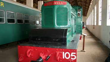
The Sierra Leone National Railway Museum was established by Col. Steve Davies MBE, Deputy Commander of the International Military Advisory Training Team (IMATT) in Sierra Leone, working in his spare time with a team of fifteen young unemployed Sierra Leoneans. Together they have transformed a shed of locomotives, abandoned since abolition of the State railway […]